Historic City Map - Washington Louisville New Orleans Cities - Bradford 1838 - 23x28 - Vintage Wall Art
Historic City Map - Washington Louisville New Orleans Cities - Bradford 1838 - 23x28 - Vintage Wall Art


Product Number: SKU:USEA0011-2
Map Print Size: 23.00 x 28.29
Metric Map Print Size: 58.42 X 71.85
Shipping: print gets shipped rolled
Couldn't load pickup availability
-
Description
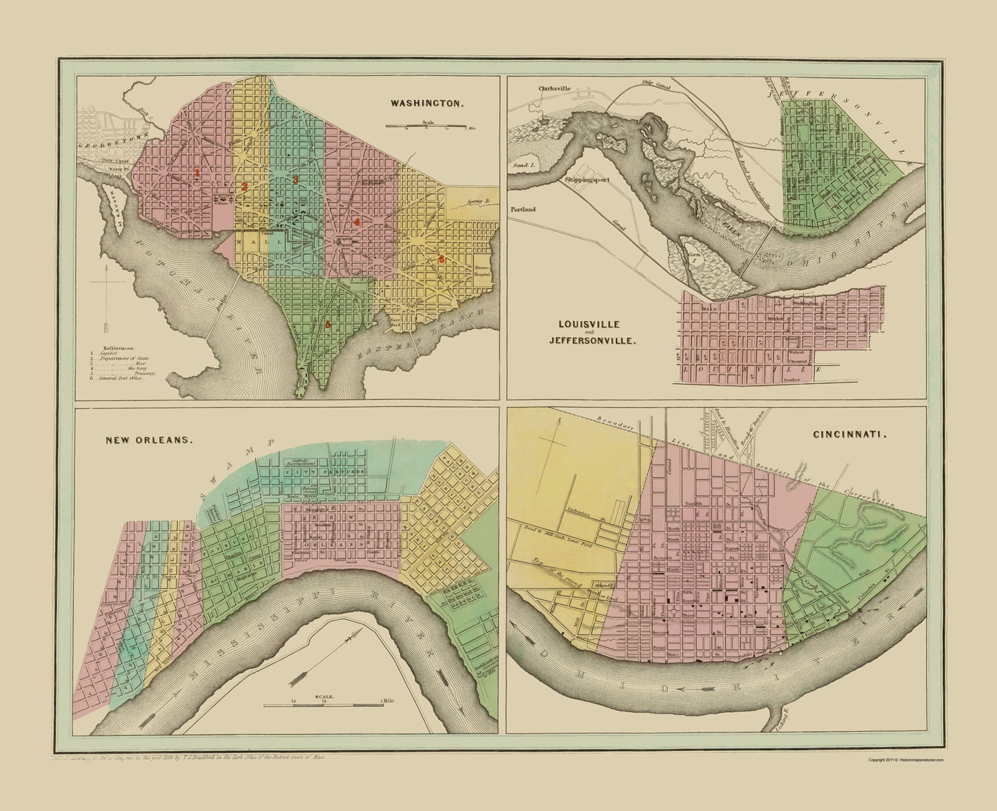
Old City Map - Washington, New Orleans 1838 - This is an exquisite full-color Reproduction printed on high-quality gloss paper, art paper or canvas.
Print Size: 23.00 x 28.29 inches
58.42 X 71.85cm
Sites and Townships Specific To This Map Are: Washington, Louisville, Jeffersonville, Cincinnati, and New Orleans.
The following towns are featured: Washington, DC showing the plat, including the mall, along the Potomac and Eastern Branch. Louisville and Jeffersonville are on opposite sides of the Ohio River, in Kentucky and Indiana. Named streets are shown in Cincinnati, on the Ohio River. New Orleans, along the banks of the Mississippi River, show the main part of the city of New Orleans, along with the other named sections of the city.
This Map is Situated in: Orleans Parish, Louisiana (LA), Hamilton County, Ohio (OH), Jefferson County, Kentucky (KY), Clark County, Indiana (IN), & District of Columbia (DC).
SKU: USEA0011
Original Maps are often difficult to find and usually have fold lines, identifying stamps or markings, tears, ragged edges, and assorted other natural signs of age that detract from their beauty. All of our maps have been professionally restored to depict their original beauty, while keeping all historical data intact.
These maps are fabulous pieces of history full of information useful to Historians, Genealogists, Cartographers, Relic Hunters, & Others. They make fascinating conversation pieces and splendid works of art for the home or office. -
Bullet Points
-
Print Quality Details
Giclée Printing Process
“A giclée (zhee-clay) reproduction is the closest duplication of an original artwork that is humanly or technically achievable. We have used the giclee printing process on both the Ultrasmooth Fine Art Paper and the Cotton Canvas options to create truly magnificent map prints, the quality of which is recognized by museums and galleries around the world. Read more about Giclee Prints here.
Glossy Satin Photo Quality
This is a very high quality, photo-grade, 7 mil thick paper. It is considered a "matte" finish, however it does have a slight sheen to it. It is a very nice paper and produces extremely attractive maps.
Matte Art Paper
This archival fine-art media has the look and feel of old-world handmade paper and is great for producing sharp, accurate reproductions. The Giclee process, combined with a 12 mil thick paper, creates magnificent historical maps guaranteed not to fade, yellow, or crack for more than 100 years. The quality of these matte-finish maps is recognized by museums and galleries around the world.
Matte Canvas
Ideal for framing, the poly/cotton blend archival-grade canvas will satisfy even the most discriminating taste. This canvas has a medium gloss finish, and after printing via the Giclee process, your historical maps are guaranteed not to fade, yellow, or crack for more than 100 years. The result is truly magnificent and ideal for those seeking the look and feel of an actual painting.
Print Size: 23.00 x 28.29 inches
58.42 X 71.85cm
Sites and Townships Specific To This Map Are: Washington, Louisville, Jeffersonville, Cincinnati, and New Orleans.
The following towns are featured: Washington, DC showing the plat, including the mall, along the Potomac and Eastern Branch. Louisville and Jeffersonville are on opposite sides of the Ohio River, in Kentucky and Indiana. Named streets are shown in Cincinnati, on the Ohio River. New Orleans, along the banks of the Mississippi River, show the main part of the city of New Orleans, along with the other named sections of the city.
This Map is Situated in: Orleans Parish, Louisiana (LA), Hamilton County, Ohio (OH), Jefferson County, Kentucky (KY), Clark County, Indiana (IN), & District of Columbia (DC).
SKU: USEA0011
Original Maps are often difficult to find and usually have fold lines, identifying stamps or markings, tears, ragged edges, and assorted other natural signs of age that detract from their beauty. All of our maps have been professionally restored to depict their original beauty, while keeping all historical data intact.
These maps are fabulous pieces of history full of information useful to Historians, Genealogists, Cartographers, Relic Hunters, & Others. They make fascinating conversation pieces and splendid works of art for the home or office.
Giclée Printing Process
“A giclée (zhee-clay) reproduction is the closest duplication of an original artwork that is humanly or technically achievable. We have used the giclee printing process on both the Ultrasmooth Fine Art Paper and the Cotton Canvas options to create truly magnificent map prints, the quality of which is recognized by museums and galleries around the world. Read more about Giclee Prints here.
Glossy Satin Photo Quality
This is a very high quality, photo-grade, 7 mil thick paper. It is considered a "matte" finish, however it does have a slight sheen to it. It is a very nice paper and produces extremely attractive maps.
Matte Art Paper
This archival fine-art media has the look and feel of old-world handmade paper and is great for producing sharp, accurate reproductions. The Giclee process, combined with a 12 mil thick paper, creates magnificent historical maps guaranteed not to fade, yellow, or crack for more than 100 years. The quality of these matte-finish maps is recognized by museums and galleries around the world.
Matte Canvas
Ideal for framing, the poly/cotton blend archival-grade canvas will satisfy even the most discriminating taste. This canvas has a medium gloss finish, and after printing via the Giclee process, your historical maps are guaranteed not to fade, yellow, or crack for more than 100 years. The result is truly magnificent and ideal for those seeking the look and feel of an actual painting.