Historic County Map - Franklin Jefferson Williamson Counties Illinois - Campbell 1870
Historic County Map - Franklin Jefferson Williamson Counties Illinois - Campbell 1870


Product Number: SKU:ILFR0001-2
Shipping: print gets shipped rolled
Couldn't load pickup availability


-
Description
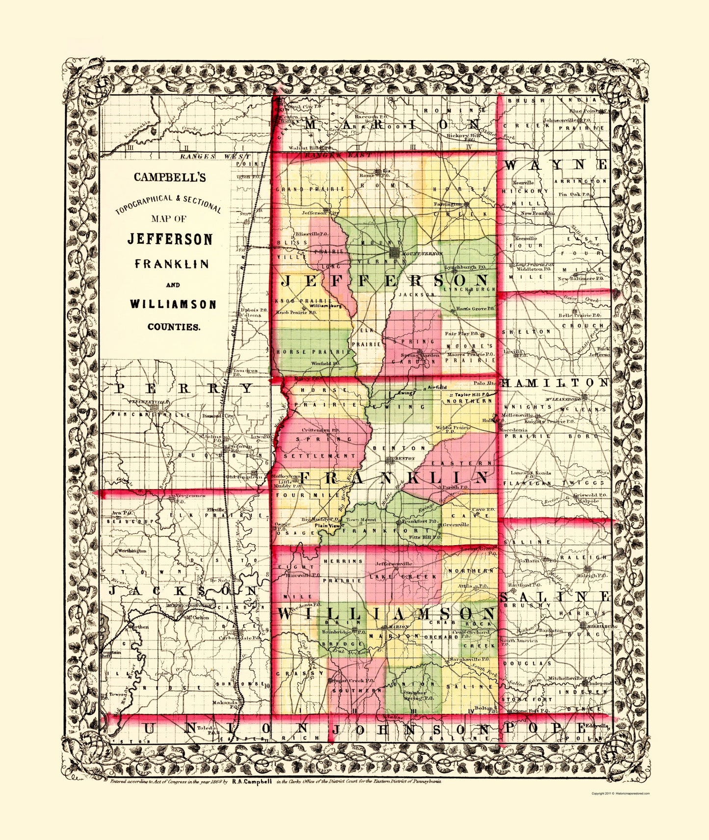
Old County Map - Franklin, Jefferson, Williamson Illinois - 1870 - This is an exquisite full-color Reproduction printed on high-quality gloss paper, art paper or canvas.
Sites and Townships Specific To This Map Are: Grand Prairie, Rome, Blissville, Prairie Long, Mount Vernon, Jackson, Knob Prairie, Horse Creek, Lynchburgh, Moores Prairie, Spring Garden, Elk Prairie, Horse Prairie, Northern, Ewing, Spring Settlement, Benton, Eastern, Four Mile, Osage, Cave, Frankport, Northern, Lake Creek, Herrins Prairie, Eight Mile, Bain Bridge, Marion, Crab Orchard, Rock Creek, Saline, Union, and Southern.
The following towns are featured: Illinois Central Railroad, Post Offices: Rome Post Office, Blissville Post Office, Lynchburgh Post Office and many more), Forks (Adams Fork, Middle Fork, and South Fork of Saline), Rivers (Big Muddy River and Little Muddy River), and Crab Orchard Creek.
This Map is Situated in: Franklin, Williamson, and Jefferson Counties, Illinois (IL)
SKU: ILFR0001
Original Maps are often difficult to find and usually have fold lines, identifying stamps or markings, tears, ragged edges, and assorted other natural signs of age that detract from their beauty. All of our maps have been professionally restored to depict their original beauty, while keeping all historical data intact.
These maps are fabulous pieces of history full of information useful to Historians, Genealogists, Cartographers, Relic Hunters, & Others. They make fascinating conversation pieces and splendid works of art for the home or office. -
Bullet Points
-
Print Quality Details
Giclée Printing Process
“A giclée (zhee-clay) reproduction is the closest duplication of an original artwork that is humanly or technically achievable. We have used the giclee printing process on both the Ultrasmooth Fine Art Paper and the Cotton Canvas options to create truly magnificent map prints, the quality of which is recognized by museums and galleries around the world. Read more about Giclee Prints here.
Glossy Satin Photo
This is a very high quality, photo-grade, 8 mil thick paper. It is considered a "matte" finish, however it does have a slight sheen to it. It is a very nice paper and produces extremely attractive maps.
Matte Art
This archival fine-art media has the look and feel of old-world handmade paper and is great for producing sharp, accurate reproductions. The Giclee process, combined with a 8 mil thick paper, creates magnificent historical maps guaranteed not to fade, yellow, or crack for more than 100 years. The quality of these matte-finish maps is recognized by museums and galleries around the world.
Sites and Townships Specific To This Map Are: Grand Prairie, Rome, Blissville, Prairie Long, Mount Vernon, Jackson, Knob Prairie, Horse Creek, Lynchburgh, Moores Prairie, Spring Garden, Elk Prairie, Horse Prairie, Northern, Ewing, Spring Settlement, Benton, Eastern, Four Mile, Osage, Cave, Frankport, Northern, Lake Creek, Herrins Prairie, Eight Mile, Bain Bridge, Marion, Crab Orchard, Rock Creek, Saline, Union, and Southern.
The following towns are featured: Illinois Central Railroad, Post Offices: Rome Post Office, Blissville Post Office, Lynchburgh Post Office and many more), Forks (Adams Fork, Middle Fork, and South Fork of Saline), Rivers (Big Muddy River and Little Muddy River), and Crab Orchard Creek.
This Map is Situated in: Franklin, Williamson, and Jefferson Counties, Illinois (IL)
SKU: ILFR0001
Original Maps are often difficult to find and usually have fold lines, identifying stamps or markings, tears, ragged edges, and assorted other natural signs of age that detract from their beauty. All of our maps have been professionally restored to depict their original beauty, while keeping all historical data intact.
These maps are fabulous pieces of history full of information useful to Historians, Genealogists, Cartographers, Relic Hunters, & Others. They make fascinating conversation pieces and splendid works of art for the home or office.
Giclée Printing Process
“A giclée (zhee-clay) reproduction is the closest duplication of an original artwork that is humanly or technically achievable. We have used the giclee printing process on both the Ultrasmooth Fine Art Paper and the Cotton Canvas options to create truly magnificent map prints, the quality of which is recognized by museums and galleries around the world. Read more about Giclee Prints here.
Glossy Satin Photo
This is a very high quality, photo-grade, 8 mil thick paper. It is considered a "matte" finish, however it does have a slight sheen to it. It is a very nice paper and produces extremely attractive maps.
Matte Art
This archival fine-art media has the look and feel of old-world handmade paper and is great for producing sharp, accurate reproductions. The Giclee process, combined with a 8 mil thick paper, creates magnificent historical maps guaranteed not to fade, yellow, or crack for more than 100 years. The quality of these matte-finish maps is recognized by museums and galleries around the world.