Historic Map - Italy - Thomson 1814 - Vintage Wall Art
Historic Map - Italy - Thomson 1814 - Vintage Wall Art


Product Number: SKU:ITIT0007-2
Shipping: print gets shipped rolled
Couldn't load pickup availability


-
Description
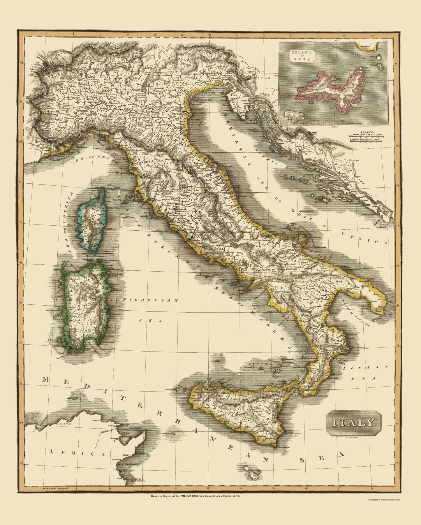
Old Italy Map - Thomson 1814 - This is an exquisite full-color Reproduction printed on high-quality gloss paper, art paper or canvas.
The following towns are featured: an example of John Thomson∆s 1814 map of Italy. Thomson∆s map of Italy covers peninsular Italy from the Alps to Calabria as well as the adjacent islands of Sicily, Sardinia, and Corsica. Parts of northern Africa and the Dalmatian coast are also included. Relief is shown in hachures with towns, cities, and major topographical features identified. Thomson issued this map shortly after the dissolution of Napoleon∆s empire in Europe. Following Napoleon∆s exile to Elba, shown here as an inset in the upper right quadrant, Italy was divided between Austria, the Kingdom of Sardinia, and the Kingdom of the Two Sicilies. Nonetheless, a sense of national solidarity has begun to emerge and the subsequent popular uprisings throughout the peninsula would soon lead to a new Kingdom of Italy and the Italian unification movement. This map is a steel plate engraving by Scott Robert and was prepared by John Thomson for inclusion in the 1814 edition of Thomson∆s
SKU: ITIT0007
Original Maps are often difficult to find and usually have fold lines, identifying stamps or markings, tears, ragged edges, and assorted other natural signs of age that detract from their beauty. All of our maps have been professionally restored to depict their original beauty, while keeping all historical data intact.
These maps are fabulous pieces of history full of information useful to Historians, Genealogists, Cartographers, Relic Hunters, & Others. They make fascinating conversation pieces and splendid works of art for the home or office. -
Bullet Points
-
Print Quality Details
Giclée Printing Process
“A giclée (zhee-clay) reproduction is the closest duplication of an original artwork that is humanly or technically achievable. We have used the giclee printing process on both the Ultrasmooth Fine Art Paper and the Cotton Canvas options to create truly magnificent map prints, the quality of which is recognized by museums and galleries around the world. Read more about Giclee Prints here.
Glossy Satin Photo
This is a very high quality, photo-grade, 8 mil thick paper. It is considered a "matte" finish, however it does have a slight sheen to it. It is a very nice paper and produces extremely attractive maps.
Matte Art
This archival fine-art media has the look and feel of old-world handmade paper and is great for producing sharp, accurate reproductions. The Giclee process, combined with a 8 mil thick paper, creates magnificent historical maps guaranteed not to fade, yellow, or crack for more than 100 years. The quality of these matte-finish maps is recognized by museums and galleries around the world.
The following towns are featured: an example of John Thomson∆s 1814 map of Italy. Thomson∆s map of Italy covers peninsular Italy from the Alps to Calabria as well as the adjacent islands of Sicily, Sardinia, and Corsica. Parts of northern Africa and the Dalmatian coast are also included. Relief is shown in hachures with towns, cities, and major topographical features identified. Thomson issued this map shortly after the dissolution of Napoleon∆s empire in Europe. Following Napoleon∆s exile to Elba, shown here as an inset in the upper right quadrant, Italy was divided between Austria, the Kingdom of Sardinia, and the Kingdom of the Two Sicilies. Nonetheless, a sense of national solidarity has begun to emerge and the subsequent popular uprisings throughout the peninsula would soon lead to a new Kingdom of Italy and the Italian unification movement. This map is a steel plate engraving by Scott Robert and was prepared by John Thomson for inclusion in the 1814 edition of Thomson∆s
SKU: ITIT0007
Original Maps are often difficult to find and usually have fold lines, identifying stamps or markings, tears, ragged edges, and assorted other natural signs of age that detract from their beauty. All of our maps have been professionally restored to depict their original beauty, while keeping all historical data intact.
These maps are fabulous pieces of history full of information useful to Historians, Genealogists, Cartographers, Relic Hunters, & Others. They make fascinating conversation pieces and splendid works of art for the home or office.
Giclée Printing Process
“A giclée (zhee-clay) reproduction is the closest duplication of an original artwork that is humanly or technically achievable. We have used the giclee printing process on both the Ultrasmooth Fine Art Paper and the Cotton Canvas options to create truly magnificent map prints, the quality of which is recognized by museums and galleries around the world. Read more about Giclee Prints here.
Glossy Satin Photo
This is a very high quality, photo-grade, 8 mil thick paper. It is considered a "matte" finish, however it does have a slight sheen to it. It is a very nice paper and produces extremely attractive maps.
Matte Art
This archival fine-art media has the look and feel of old-world handmade paper and is great for producing sharp, accurate reproductions. The Giclee process, combined with a 8 mil thick paper, creates magnificent historical maps guaranteed not to fade, yellow, or crack for more than 100 years. The quality of these matte-finish maps is recognized by museums and galleries around the world.