Historic Nautical Map - Gulf Stream Atlantic Ocean US Canada - Franklin 1786
Historic Nautical Map - Gulf Stream Atlantic Ocean US Canada - Franklin 1786


Product Number: SKU:ITGU0011-2
Shipping: print gets shipped rolled
Couldn't load pickup availability


-
Description
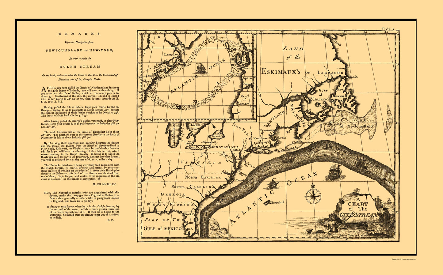
Old Northern Hemisphere Map - Gulf Stream Atlantic Ocean - Franklin 1786 - This is an exquisite full-color Reproduction printed on high-quality gloss paper, art paper or canvas.
The following towns are featured: Benjamin Franklin's Chart of the Gulf Stream and accompanying letter, which appeared in the the Transactions of the American Philosophical Society in 1786. Franklin's map is one of the earliest to provide a detailed depiction of the Gulf Stream, pre-dated only by several virtually unobtainable maps prepared at Franklin's direction in London and Paris. The accompanying remarks provide Franklin's own comments on the location of the Gulf Stream, based upon his observations and the observations of his nephew, Timothy Folger, who assisted Franklin in compiling the information necessary to make this initial charting of the Gulf Stream. The Gulf Stream is one of the most important natural phenomenon affecting navigators in the Atlantic Ocean. First named by Benjamin Franklin, the Gulf Stream is a high speed river within the ocean, flowing from the Gulf of Mexico, around the southern tip of Florida and along the East Coast
SKU: ITGU0011
Original Maps are often difficult to find and usually have fold lines, identifying stamps or markings, tears, ragged edges, and assorted other natural signs of age that detract from their beauty. All of our maps have been professionally restored to depict their original beauty, while keeping all historical data intact.
These maps are fabulous pieces of history full of information useful to Historians, Genealogists, Cartographers, Relic Hunters, & Others. They make fascinating conversation pieces and splendid works of art for the home or office. -
Bullet Points
-
Print Quality Details
Giclée Printing Process
“A giclée (zhee-clay) reproduction is the closest duplication of an original artwork that is humanly or technically achievable. We have used the giclee printing process on both the Ultrasmooth Fine Art Paper and the Cotton Canvas options to create truly magnificent map prints, the quality of which is recognized by museums and galleries around the world. Read more about Giclee Prints here.
Glossy Satin Photo
This is a very high quality, photo-grade, 8 mil thick paper. It is considered a "matte" finish, however it does have a slight sheen to it. It is a very nice paper and produces extremely attractive maps.
Matte Art
This archival fine-art media has the look and feel of old-world handmade paper and is great for producing sharp, accurate reproductions. The Giclee process, combined with a 8 mil thick paper, creates magnificent historical maps guaranteed not to fade, yellow, or crack for more than 100 years. The quality of these matte-finish maps is recognized by museums and galleries around the world.
The following towns are featured: Benjamin Franklin's Chart of the Gulf Stream and accompanying letter, which appeared in the the Transactions of the American Philosophical Society in 1786. Franklin's map is one of the earliest to provide a detailed depiction of the Gulf Stream, pre-dated only by several virtually unobtainable maps prepared at Franklin's direction in London and Paris. The accompanying remarks provide Franklin's own comments on the location of the Gulf Stream, based upon his observations and the observations of his nephew, Timothy Folger, who assisted Franklin in compiling the information necessary to make this initial charting of the Gulf Stream. The Gulf Stream is one of the most important natural phenomenon affecting navigators in the Atlantic Ocean. First named by Benjamin Franklin, the Gulf Stream is a high speed river within the ocean, flowing from the Gulf of Mexico, around the southern tip of Florida and along the East Coast
SKU: ITGU0011
Original Maps are often difficult to find and usually have fold lines, identifying stamps or markings, tears, ragged edges, and assorted other natural signs of age that detract from their beauty. All of our maps have been professionally restored to depict their original beauty, while keeping all historical data intact.
These maps are fabulous pieces of history full of information useful to Historians, Genealogists, Cartographers, Relic Hunters, & Others. They make fascinating conversation pieces and splendid works of art for the home or office.
Giclée Printing Process
“A giclée (zhee-clay) reproduction is the closest duplication of an original artwork that is humanly or technically achievable. We have used the giclee printing process on both the Ultrasmooth Fine Art Paper and the Cotton Canvas options to create truly magnificent map prints, the quality of which is recognized by museums and galleries around the world. Read more about Giclee Prints here.
Glossy Satin Photo
This is a very high quality, photo-grade, 8 mil thick paper. It is considered a "matte" finish, however it does have a slight sheen to it. It is a very nice paper and produces extremely attractive maps.
Matte Art
This archival fine-art media has the look and feel of old-world handmade paper and is great for producing sharp, accurate reproductions. The Giclee process, combined with a 8 mil thick paper, creates magnificent historical maps guaranteed not to fade, yellow, or crack for more than 100 years. The quality of these matte-finish maps is recognized by museums and galleries around the world.