Historic Nautical Map - Orinoco River Venezuela Colombia - Humboldt 1732 - Vintage Wall Art
Historic Nautical Map - Orinoco River Venezuela Colombia - Humboldt 1732 - Vintage Wall Art


Product Number: SKU:ITOR0001-2
Shipping: print gets shipped rolled
Couldn't load pickup availability


-
Description
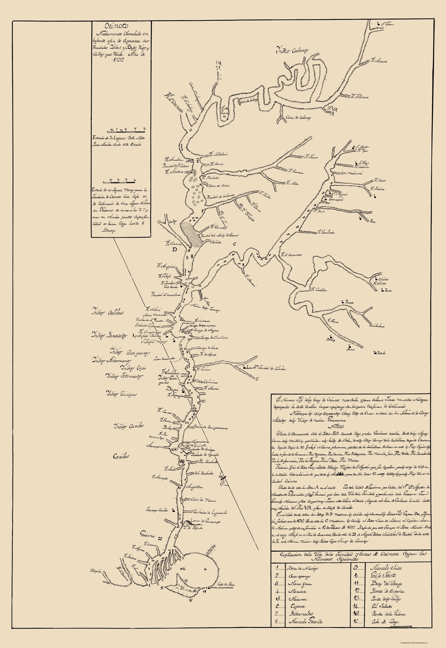
Old South America Map - Orinoco River, Venezuela and Colombia 1732 - This is an exquisite full-color Reproduction printed on high-quality gloss paper, art paper or canvas.
Sites and Townships Specific To This Map Are: Guaiana.
The following towns are featured: the Orinoco is one of the longest rivers in South America at 1,330 mi. Its drainage basin, sometimes called the Orinoquia, covers 340,000 sq mi, with 76.3% of it in Venezuela and the remainder in Colombia. The Orinoco and its tributaries are the major transportation system for Eastern and interior Venezuela and the llanos of Colombia. This map of the Orinoco River that includes visible islands and tributaries at the delta of the river. This early 18th century map of the valley of the Orinoco River contains extensive information about the Indian nations bordering the river, Christian missions, and other settlements. Shown are streams that flow into the Orinoco, and navigational hazards and islands. The map includes a keyed index and a detailed historical note on the exploration of the river from 1682 to 1732. The note contains information about the martyrdom of several religious figures. As indicated in the no
SKU: ITOR0001
Original Maps are often difficult to find and usually have fold lines, identifying stamps or markings, tears, ragged edges, and assorted other natural signs of age that detract from their beauty. All of our maps have been professionally restored to depict their original beauty, while keeping all historical data intact.
These maps are fabulous pieces of history full of information useful to Historians, Genealogists, Cartographers, Relic Hunters, & Others. They make fascinating conversation pieces and splendid works of art for the home or office. -
Bullet Points
-
Print Quality Details
Giclée Printing Process
“A giclée (zhee-clay) reproduction is the closest duplication of an original artwork that is humanly or technically achievable. We have used the giclee printing process on both the Ultrasmooth Fine Art Paper and the Cotton Canvas options to create truly magnificent map prints, the quality of which is recognized by museums and galleries around the world. Read more about Giclee Prints here.
Glossy Satin Photo
This is a very high quality, photo-grade, 8 mil thick paper. It is considered a "matte" finish, however it does have a slight sheen to it. It is a very nice paper and produces extremely attractive maps.
Matte Art
This archival fine-art media has the look and feel of old-world handmade paper and is great for producing sharp, accurate reproductions. The Giclee process, combined with a 8 mil thick paper, creates magnificent historical maps guaranteed not to fade, yellow, or crack for more than 100 years. The quality of these matte-finish maps is recognized by museums and galleries around the world.
Sites and Townships Specific To This Map Are: Guaiana.
The following towns are featured: the Orinoco is one of the longest rivers in South America at 1,330 mi. Its drainage basin, sometimes called the Orinoquia, covers 340,000 sq mi, with 76.3% of it in Venezuela and the remainder in Colombia. The Orinoco and its tributaries are the major transportation system for Eastern and interior Venezuela and the llanos of Colombia. This map of the Orinoco River that includes visible islands and tributaries at the delta of the river. This early 18th century map of the valley of the Orinoco River contains extensive information about the Indian nations bordering the river, Christian missions, and other settlements. Shown are streams that flow into the Orinoco, and navigational hazards and islands. The map includes a keyed index and a detailed historical note on the exploration of the river from 1682 to 1732. The note contains information about the martyrdom of several religious figures. As indicated in the no
SKU: ITOR0001
Original Maps are often difficult to find and usually have fold lines, identifying stamps or markings, tears, ragged edges, and assorted other natural signs of age that detract from their beauty. All of our maps have been professionally restored to depict their original beauty, while keeping all historical data intact.
These maps are fabulous pieces of history full of information useful to Historians, Genealogists, Cartographers, Relic Hunters, & Others. They make fascinating conversation pieces and splendid works of art for the home or office.
Giclée Printing Process
“A giclée (zhee-clay) reproduction is the closest duplication of an original artwork that is humanly or technically achievable. We have used the giclee printing process on both the Ultrasmooth Fine Art Paper and the Cotton Canvas options to create truly magnificent map prints, the quality of which is recognized by museums and galleries around the world. Read more about Giclee Prints here.
Glossy Satin Photo
This is a very high quality, photo-grade, 8 mil thick paper. It is considered a "matte" finish, however it does have a slight sheen to it. It is a very nice paper and produces extremely attractive maps.
Matte Art
This archival fine-art media has the look and feel of old-world handmade paper and is great for producing sharp, accurate reproductions. The Giclee process, combined with a 8 mil thick paper, creates magnificent historical maps guaranteed not to fade, yellow, or crack for more than 100 years. The quality of these matte-finish maps is recognized by museums and galleries around the world.