Historic Panoramic View - Westerly Rhode Island - Bailey 1877 - Vintage Wall Art
Historic Panoramic View - Westerly Rhode Island - Bailey 1877 - Vintage Wall Art


Product Number: SKU:RIWE0001-2
Shipping: print gets shipped rolled
Couldn't load pickup availability


-
Description
Panoramic Print - Westerly Rhode Island - Bailey 1877 - This is an exquisite full-color Reproduction printed on high-quality gloss paper, art paper or canvas.
Sites and Townships Specific To This Map Are: Westerly.
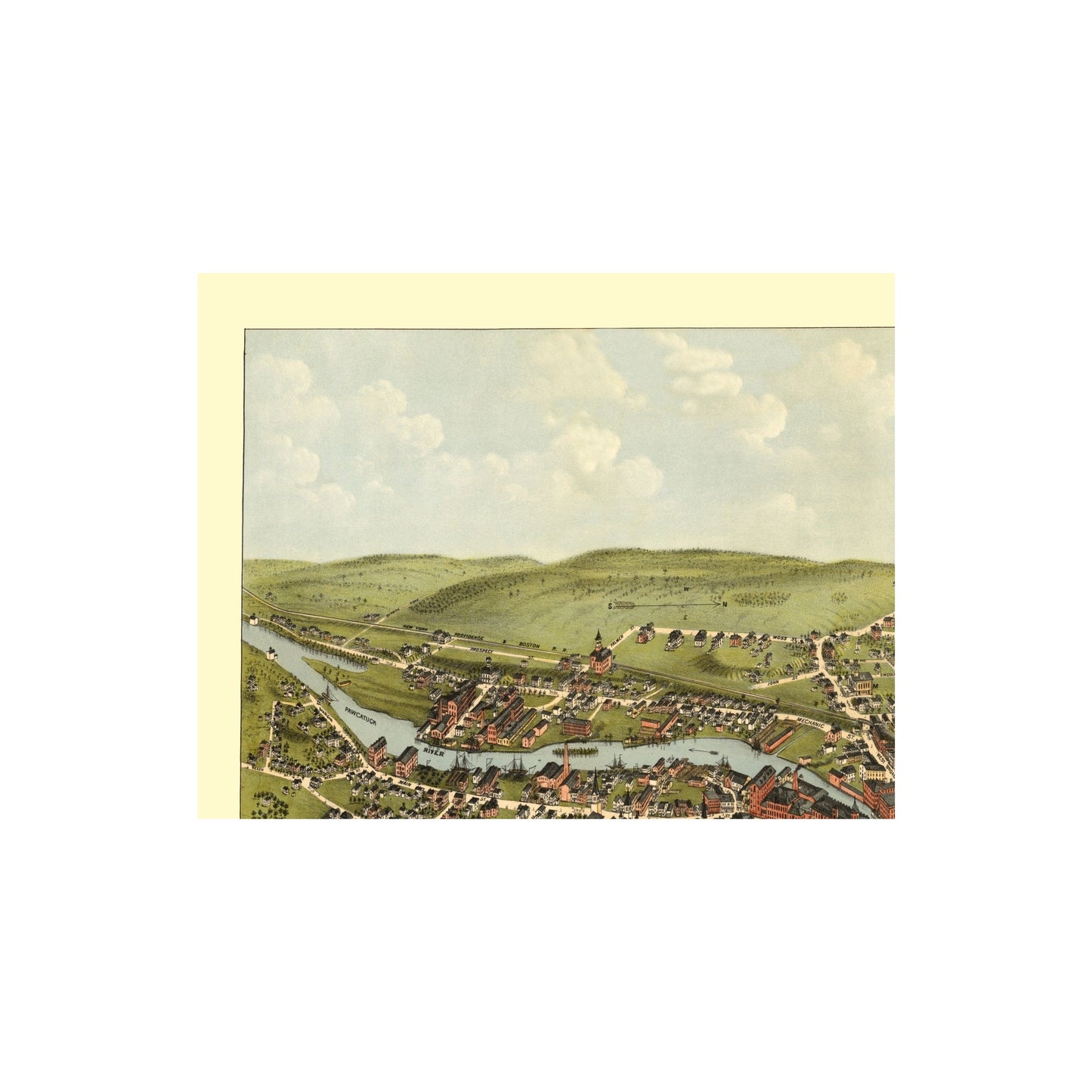
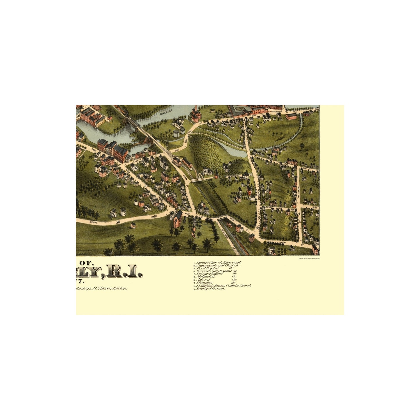
The following towns are featured: this bird∆s-eye view of Westerly, Rhode Island was drawn and published by O. H. Bailey & J. C. Hazen in 1877. Westerly was established in the 1600's near the location were the Pawcatuck River flows into Narragansett Bay. Westerly was noteworthy in its early years as a vacation and fishing village. There was one fresh-water pond and three salt-water ponds nearby that were abundant with fish. Granite and other stones of varied value began to be quarried aggressively in the mid-1800's near Westerly. The most valued granite quarried here was used in forming many of the famous statues and monuments of New England. The illustration shows labeled streets, bridges, buildings and railroad route. An alphabetical table references manufacturing companies, monument companies, government offices, hotels, and churches.
This Map is Situated in: Washington County, Rhode Island (RI).
SKU: RIWE0001
Original Maps are often difficult to find and usually have fold lines, identifying stamps or markings, tears, ragged edges, and assorted other natural signs of age that detract from their beauty. All of our maps have been professionally restored to depict their original beauty, while keeping all historical data intact.
These maps are fabulous pieces of history full of information useful to Historians, Genealogists, Cartographers, Relic Hunters, & Others. They make fascinating conversation pieces and splendid works of art for the home or office. -
Bullet Points
-
Print Quality Details
Giclée Printing Process
“A giclée (zhee-clay) reproduction is the closest duplication of an original artwork that is humanly or technically achievable. We have used the giclee printing process on both the Ultrasmooth Fine Art Paper and the Cotton Canvas options to create truly magnificent map prints, the quality of which is recognized by museums and galleries around the world. Read more about Giclee Prints here.
Glossy Satin Photo
This is a very high quality, photo-grade, 8 mil thick paper. It is considered a "matte" finish, however it does have a slight sheen to it. It is a very nice paper and produces extremely attractive maps.
Matte Art
This archival fine-art media has the look and feel of old-world handmade paper and is great for producing sharp, accurate reproductions. The Giclee process, combined with a 8 mil thick paper, creates magnificent historical maps guaranteed not to fade, yellow, or crack for more than 100 years. The quality of these matte-finish maps is recognized by museums and galleries around the world.
Sites and Townships Specific To This Map Are: Westerly.
The following towns are featured: this bird∆s-eye view of Westerly, Rhode Island was drawn and published by O. H. Bailey & J. C. Hazen in 1877. Westerly was established in the 1600's near the location were the Pawcatuck River flows into Narragansett Bay. Westerly was noteworthy in its early years as a vacation and fishing village. There was one fresh-water pond and three salt-water ponds nearby that were abundant with fish. Granite and other stones of varied value began to be quarried aggressively in the mid-1800's near Westerly. The most valued granite quarried here was used in forming many of the famous statues and monuments of New England. The illustration shows labeled streets, bridges, buildings and railroad route. An alphabetical table references manufacturing companies, monument companies, government offices, hotels, and churches.
This Map is Situated in: Washington County, Rhode Island (RI).
SKU: RIWE0001
Original Maps are often difficult to find and usually have fold lines, identifying stamps or markings, tears, ragged edges, and assorted other natural signs of age that detract from their beauty. All of our maps have been professionally restored to depict their original beauty, while keeping all historical data intact.
These maps are fabulous pieces of history full of information useful to Historians, Genealogists, Cartographers, Relic Hunters, & Others. They make fascinating conversation pieces and splendid works of art for the home or office.
Giclée Printing Process
“A giclée (zhee-clay) reproduction is the closest duplication of an original artwork that is humanly or technically achievable. We have used the giclee printing process on both the Ultrasmooth Fine Art Paper and the Cotton Canvas options to create truly magnificent map prints, the quality of which is recognized by museums and galleries around the world. Read more about Giclee Prints here.
Glossy Satin Photo
This is a very high quality, photo-grade, 8 mil thick paper. It is considered a "matte" finish, however it does have a slight sheen to it. It is a very nice paper and produces extremely attractive maps.
Matte Art
This archival fine-art media has the look and feel of old-world handmade paper and is great for producing sharp, accurate reproductions. The Giclee process, combined with a 8 mil thick paper, creates magnificent historical maps guaranteed not to fade, yellow, or crack for more than 100 years. The quality of these matte-finish maps is recognized by museums and galleries around the world.