Historic State Map - Alaska - USCS 1873 - Vintage Wall Art
Historic State Map - Alaska - USCS 1873 - Vintage Wall Art


Product Number: SKU:AKNW0001-2
Shipping: print gets shipped rolled
Couldn't load pickup availability


-
Description
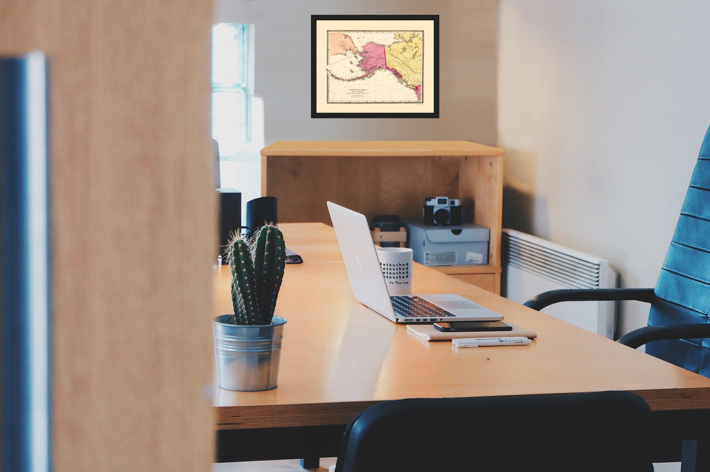
Old State Map - Alaska, British Territories, Siberia - USCS 1873 - This is an exquisite full-color Reproduction printed on high-quality gloss paper, art paper or canvas.
Sites and Townships Specific To This Map Are: Olympia, Salem, New Westminister, Fort Yukon, Katmay, Tokhakat, Alexandrovsk, Souworoff, Fort Alexander, Napasiak, Nukluatmut, Kaimut, Makimut, Tijgeliede, Bojitshagat, Tugoutagag, Kakoghat, Sesualing, nig-a-lek, Red Koulmakoff, Odinotekehka, Fort Simpson, and Sitka.
The following towns are featured: States and Territories are bordered in red: Alaska, British Territories, Washington Territory, and Siberia. The boundary between Russia and the United states is visible. Arctic Ocean, Behring Sea, North Pacific, Behring Strait and the Gulf of Anadir are included as well. Geography: Chigmit Mts., Cippewayan Rocky Mts. Mt. St. Elias, and Mt. Fairweather; Aliaska Peninsula, Koliac Island, Queen Charlotte Island, Lawrence Island, Aleutian Islands and many more; River Yukon, Kouskolevin River, Mackenizie River and many smaller rivers; Manitoba Lake, Great Bear Lake, Great Star Lake. Latitude and Longitude are included. Scale of Statute miles - 0-
SKU: AKNW0001
Original Maps are often difficult to find and usually have fold lines, identifying stamps or markings, tears, ragged edges, and assorted other natural signs of age that detract from their beauty. All of our maps have been professionally restored to depict their original beauty, while keeping all historical data intact.
These maps are fabulous pieces of history full of information useful to Historians, Genealogists, Cartographers, Relic Hunters, & Others. They make fascinating conversation pieces and splendid works of art for the home or office. -
Bullet Points
-
Print Quality Details
Giclée Printing Process
“A giclée (zhee-clay) reproduction is the closest duplication of an original artwork that is humanly or technically achievable. We have used the giclee printing process on both the Ultrasmooth Fine Art Paper and the Cotton Canvas options to create truly magnificent map prints, the quality of which is recognized by museums and galleries around the world. Read more about Giclee Prints here.
Glossy Satin Photo
This is a very high quality, photo-grade, 8 mil thick paper. It is considered a "matte" finish, however it does have a slight sheen to it. It is a very nice paper and produces extremely attractive maps.
Matte Art
This archival fine-art media has the look and feel of old-world handmade paper and is great for producing sharp, accurate reproductions. The Giclee process, combined with a 8 mil thick paper, creates magnificent historical maps guaranteed not to fade, yellow, or crack for more than 100 years. The quality of these matte-finish maps is recognized by museums and galleries around the world.
Sites and Townships Specific To This Map Are: Olympia, Salem, New Westminister, Fort Yukon, Katmay, Tokhakat, Alexandrovsk, Souworoff, Fort Alexander, Napasiak, Nukluatmut, Kaimut, Makimut, Tijgeliede, Bojitshagat, Tugoutagag, Kakoghat, Sesualing, nig-a-lek, Red Koulmakoff, Odinotekehka, Fort Simpson, and Sitka.
The following towns are featured: States and Territories are bordered in red: Alaska, British Territories, Washington Territory, and Siberia. The boundary between Russia and the United states is visible. Arctic Ocean, Behring Sea, North Pacific, Behring Strait and the Gulf of Anadir are included as well. Geography: Chigmit Mts., Cippewayan Rocky Mts. Mt. St. Elias, and Mt. Fairweather; Aliaska Peninsula, Koliac Island, Queen Charlotte Island, Lawrence Island, Aleutian Islands and many more; River Yukon, Kouskolevin River, Mackenizie River and many smaller rivers; Manitoba Lake, Great Bear Lake, Great Star Lake. Latitude and Longitude are included. Scale of Statute miles - 0-
SKU: AKNW0001
Original Maps are often difficult to find and usually have fold lines, identifying stamps or markings, tears, ragged edges, and assorted other natural signs of age that detract from their beauty. All of our maps have been professionally restored to depict their original beauty, while keeping all historical data intact.
These maps are fabulous pieces of history full of information useful to Historians, Genealogists, Cartographers, Relic Hunters, & Others. They make fascinating conversation pieces and splendid works of art for the home or office.
Giclée Printing Process
“A giclée (zhee-clay) reproduction is the closest duplication of an original artwork that is humanly or technically achievable. We have used the giclee printing process on both the Ultrasmooth Fine Art Paper and the Cotton Canvas options to create truly magnificent map prints, the quality of which is recognized by museums and galleries around the world. Read more about Giclee Prints here.
Glossy Satin Photo
This is a very high quality, photo-grade, 8 mil thick paper. It is considered a "matte" finish, however it does have a slight sheen to it. It is a very nice paper and produces extremely attractive maps.
Matte Art
This archival fine-art media has the look and feel of old-world handmade paper and is great for producing sharp, accurate reproductions. The Giclee process, combined with a 8 mil thick paper, creates magnificent historical maps guaranteed not to fade, yellow, or crack for more than 100 years. The quality of these matte-finish maps is recognized by museums and galleries around the world.