Historic State Map - North Carolina - Bayly 1770 - Vintage Wall Art
Historic State Map - North Carolina - Bayly 1770 - Vintage Wall Art


Product Number: SKU:NCZZ0008-2
Shipping: print gets shipped rolled
Couldn't load pickup availability


-
Description
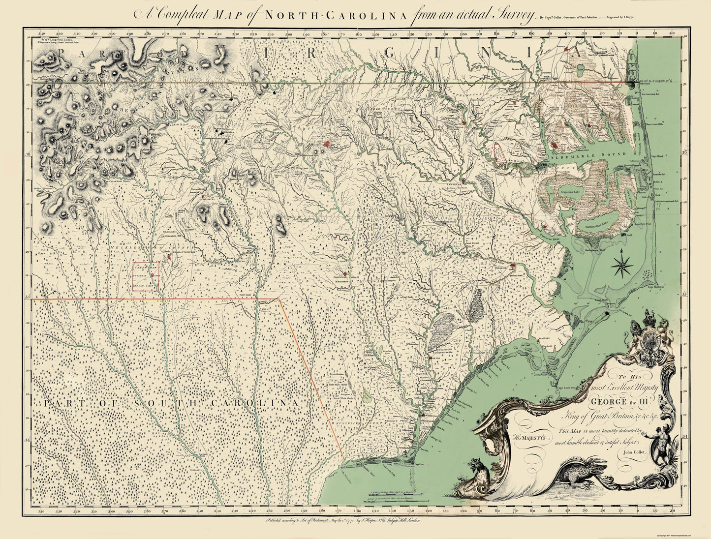
Old State Map - North Carolina - Bayly 1770 - This is an exquisite full-color Reproduction printed on high-quality gloss paper, art paper or canvas.
Sites and Townships Specific To This Map Are: The Blue Ridge or the Alagany Mountains, Brush Mountains, Yadkin River, Table Mountain, The Catawbaw River, New River, Meadow Mountain, Catawbaw Indian Tribe, Mills, Broad River, Tyger River, Sandy River, Waterree River, Congaree River, Enoree River, Path to the Cherokee Nation, Salude River, Part of South Carolina, Savannah River, Little River, Waggomaw River, Long Bay Little River Inlet, Shallot Inlet, Little Padee River, Brown Meadow, Little White Marsh, Great White Marsh, Waggomaw Lake, Great Pedee River, N. West River, Yadkin River, Deep River, Rockey River, Haw River, Black River, Dan River, Roanoke River, Mt. Eyre, Court House, Cohary Swamp, Grove Swamp, New River, Cape Fear River, Fort Johnston, White House, Trent River, Govorners House, Chowan River, Chaples, Meherrin River, Nottaway River, Cyprus Swamp, Black Water River, Great Dismal Swamp, Perquimans River, Albemarle Sound, Scuponing River, Scuponung Lake, The Great Alegator Dismal Swamp, Great Alegator River, Ale
SKU: NCZZ0008
Original Maps are often difficult to find and usually have fold lines, identifying stamps or markings, tears, ragged edges, and assorted other natural signs of age that detract from their beauty. All of our maps have been professionally restored to depict their original beauty, while keeping all historical data intact.
These maps are fabulous pieces of history full of information useful to Historians, Genealogists, Cartographers, Relic Hunters, & Others. They make fascinating conversation pieces and splendid works of art for the home or office. -
Bullet Points
-
Print Quality Details
Giclée Printing Process
“A giclée (zhee-clay) reproduction is the closest duplication of an original artwork that is humanly or technically achievable. We have used the giclee printing process on both the Ultrasmooth Fine Art Paper and the Cotton Canvas options to create truly magnificent map prints, the quality of which is recognized by museums and galleries around the world. Read more about Giclee Prints here.
Glossy Satin Photo
This is a very high quality, photo-grade, 8 mil thick paper. It is considered a "matte" finish, however it does have a slight sheen to it. It is a very nice paper and produces extremely attractive maps.
Matte Art
This archival fine-art media has the look and feel of old-world handmade paper and is great for producing sharp, accurate reproductions. The Giclee process, combined with a 8 mil thick paper, creates magnificent historical maps guaranteed not to fade, yellow, or crack for more than 100 years. The quality of these matte-finish maps is recognized by museums and galleries around the world.
Sites and Townships Specific To This Map Are: The Blue Ridge or the Alagany Mountains, Brush Mountains, Yadkin River, Table Mountain, The Catawbaw River, New River, Meadow Mountain, Catawbaw Indian Tribe, Mills, Broad River, Tyger River, Sandy River, Waterree River, Congaree River, Enoree River, Path to the Cherokee Nation, Salude River, Part of South Carolina, Savannah River, Little River, Waggomaw River, Long Bay Little River Inlet, Shallot Inlet, Little Padee River, Brown Meadow, Little White Marsh, Great White Marsh, Waggomaw Lake, Great Pedee River, N. West River, Yadkin River, Deep River, Rockey River, Haw River, Black River, Dan River, Roanoke River, Mt. Eyre, Court House, Cohary Swamp, Grove Swamp, New River, Cape Fear River, Fort Johnston, White House, Trent River, Govorners House, Chowan River, Chaples, Meherrin River, Nottaway River, Cyprus Swamp, Black Water River, Great Dismal Swamp, Perquimans River, Albemarle Sound, Scuponing River, Scuponung Lake, The Great Alegator Dismal Swamp, Great Alegator River, Ale
SKU: NCZZ0008
Original Maps are often difficult to find and usually have fold lines, identifying stamps or markings, tears, ragged edges, and assorted other natural signs of age that detract from their beauty. All of our maps have been professionally restored to depict their original beauty, while keeping all historical data intact.
These maps are fabulous pieces of history full of information useful to Historians, Genealogists, Cartographers, Relic Hunters, & Others. They make fascinating conversation pieces and splendid works of art for the home or office.
Giclée Printing Process
“A giclée (zhee-clay) reproduction is the closest duplication of an original artwork that is humanly or technically achievable. We have used the giclee printing process on both the Ultrasmooth Fine Art Paper and the Cotton Canvas options to create truly magnificent map prints, the quality of which is recognized by museums and galleries around the world. Read more about Giclee Prints here.
Glossy Satin Photo
This is a very high quality, photo-grade, 8 mil thick paper. It is considered a "matte" finish, however it does have a slight sheen to it. It is a very nice paper and produces extremely attractive maps.
Matte Art
This archival fine-art media has the look and feel of old-world handmade paper and is great for producing sharp, accurate reproductions. The Giclee process, combined with a 8 mil thick paper, creates magnificent historical maps guaranteed not to fade, yellow, or crack for more than 100 years. The quality of these matte-finish maps is recognized by museums and galleries around the world.