Topographical Map - Bitterroot Range Montana Idaho Wyoming Sheet - USAF 1961 - Vintage Wall Art
Topographical Map - Bitterroot Range Montana Idaho Wyoming Sheet - USAF 1961 - Vintage Wall Art


Product Number: SKU:MTBR0001-2
Shipping: print gets shipped rolled
Couldn't load pickup availability


-
Description
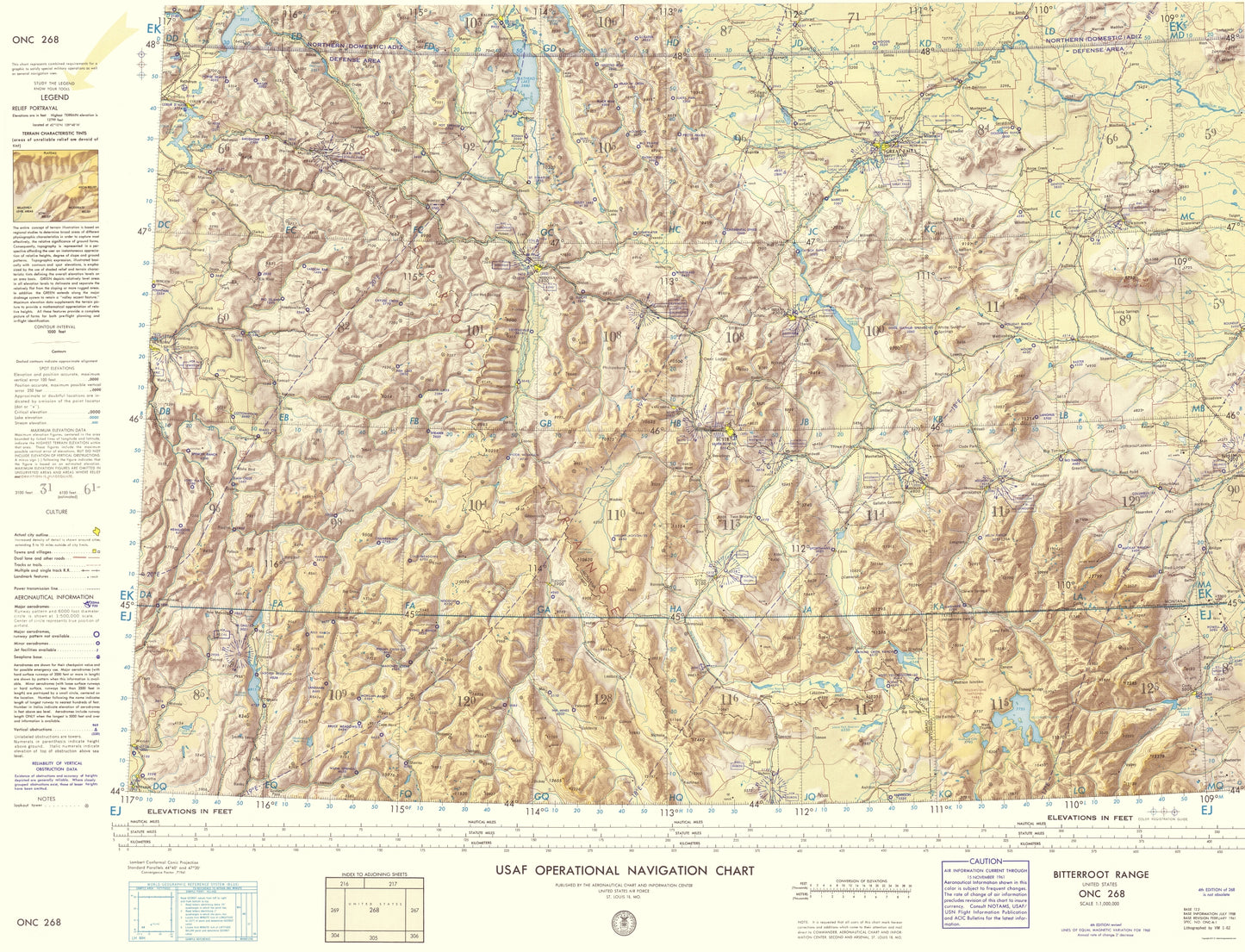
Topographical Map - Bitterroot Range Montana, Idaho, Wyoming 1961 - This is an exquisite full-color Reproduction printed on high-quality gloss paper, art paper or canvas.
Sites and Townships Specific To This Map Are: Weiser, Payette, Cody, Powell, Columbus, Livingston, Billings, Harlowton and Great Falls among many others.
The following towns are featured: The Bitterroot Range in Montana/Idaho/Wyoming, surveyed by and for the U.S. Air Force. This type of map focuses on elevation, bodies of water, roadways and aeronautical information. The entire concept of terrain illustration is based on regional studies to determine broad areas of different physiographic characteristics in order to capture the relative significance of ground forms. Features of note include: Yellowstone National Park, Flathead Lake, Coeur D' Alene Lake, Pend Orielle Lake, Missouri River, Yellowstone River, White Sulphur Springs, Red Rock River and Absaroka Range. Along the bottom of the map is an index of adjoining sheets and a series of distance scale. The map legend runs along the left side.
This Map is Situated in: Montana, Idaho and Wyoming (MT/ID/WY)
SKU: MTBR0001
Original Maps are often difficult to find and usually have fold lines, identifying stamps or markings, tears, ragged edges, and assorted other natural signs of age that detract from their beauty. All of our maps have been professionally restored to depict their original beauty, while keeping all historical data intact.
These maps are fabulous pieces of history full of information useful to Historians, Genealogists, Cartographers, Relic Hunters, & Others. They make fascinating conversation pieces and splendid works of art for the home or office. -
Bullet Points
-
Print Quality Details
Giclée Printing Process
“A giclée (zhee-clay) reproduction is the closest duplication of an original artwork that is humanly or technically achievable. We have used the giclee printing process on both the Ultrasmooth Fine Art Paper and the Cotton Canvas options to create truly magnificent map prints, the quality of which is recognized by museums and galleries around the world. Read more about Giclee Prints here.
Glossy Satin Photo
This is a very high quality, photo-grade, 8 mil thick paper. It is considered a "matte" finish, however it does have a slight sheen to it. It is a very nice paper and produces extremely attractive maps.
Matte Art
This archival fine-art media has the look and feel of old-world handmade paper and is great for producing sharp, accurate reproductions. The Giclee process, combined with a 8 mil thick paper, creates magnificent historical maps guaranteed not to fade, yellow, or crack for more than 100 years. The quality of these matte-finish maps is recognized by museums and galleries around the world.
Sites and Townships Specific To This Map Are: Weiser, Payette, Cody, Powell, Columbus, Livingston, Billings, Harlowton and Great Falls among many others.
The following towns are featured: The Bitterroot Range in Montana/Idaho/Wyoming, surveyed by and for the U.S. Air Force. This type of map focuses on elevation, bodies of water, roadways and aeronautical information. The entire concept of terrain illustration is based on regional studies to determine broad areas of different physiographic characteristics in order to capture the relative significance of ground forms. Features of note include: Yellowstone National Park, Flathead Lake, Coeur D' Alene Lake, Pend Orielle Lake, Missouri River, Yellowstone River, White Sulphur Springs, Red Rock River and Absaroka Range. Along the bottom of the map is an index of adjoining sheets and a series of distance scale. The map legend runs along the left side.
This Map is Situated in: Montana, Idaho and Wyoming (MT/ID/WY)
SKU: MTBR0001
Original Maps are often difficult to find and usually have fold lines, identifying stamps or markings, tears, ragged edges, and assorted other natural signs of age that detract from their beauty. All of our maps have been professionally restored to depict their original beauty, while keeping all historical data intact.
These maps are fabulous pieces of history full of information useful to Historians, Genealogists, Cartographers, Relic Hunters, & Others. They make fascinating conversation pieces and splendid works of art for the home or office.
Giclée Printing Process
“A giclée (zhee-clay) reproduction is the closest duplication of an original artwork that is humanly or technically achievable. We have used the giclee printing process on both the Ultrasmooth Fine Art Paper and the Cotton Canvas options to create truly magnificent map prints, the quality of which is recognized by museums and galleries around the world. Read more about Giclee Prints here.
Glossy Satin Photo
This is a very high quality, photo-grade, 8 mil thick paper. It is considered a "matte" finish, however it does have a slight sheen to it. It is a very nice paper and produces extremely attractive maps.
Matte Art
This archival fine-art media has the look and feel of old-world handmade paper and is great for producing sharp, accurate reproductions. The Giclee process, combined with a 8 mil thick paper, creates magnificent historical maps guaranteed not to fade, yellow, or crack for more than 100 years. The quality of these matte-finish maps is recognized by museums and galleries around the world.