Topographical Map - New Mexico Central New Mexico Sheet - US Army 1877 - Vintage Wall Art
Topographical Map - New Mexico Central New Mexico Sheet - US Army 1877 - Vintage Wall Art


Product Number: SKU:NMZZ0023-2
Shipping: print gets shipped rolled
Couldn't load pickup availability


-
Description
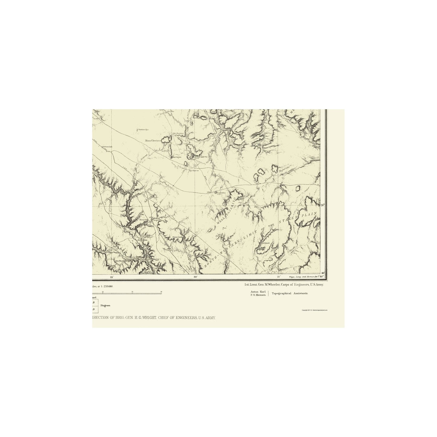
Topographical Map - New Mexico, Central New Mexico - US Army 1877 - This is an exquisite full-color Reproduction printed on high-quality gloss paper, art paper or canvas.
Sites and Townships Specific To This Map Are: Las Vegas, Paertocito, Tanques, Ojo Alamitos, Torres, Chuparrito, Los Fuertes, Liendre, Juanita, Bernal, San Jose, San Miguel, Placita, Gerrito, Anton Chico, Los Estaritos, La Cueva, Chiquita, Santa Rosa, Gidding and many others.
The following towns are featured: the Atchison and Santa Fe R.R., Pecos River, Canadian River, Whittemore's River, Taylor's River, Tecolote Creek, Gallinas Creek, Agua de la Yegua, Salt Creek, Vermejo Creek, Conchas Creek, Conchas Springs, Sabino Springs, San Geronimo Peak, Cuervito Peak, Rincon Olquin, Rincon Colorado, Rincon del Mesteno, Rincon Auga de la Yegua, Rincon Corazon, Rincon Vega, San Augustin Valley, Rincon Chupains, Bernal Hill, Mesa Barredera, Mesa Pino, Mesa Lauriano, Mesa Aguilar, Chupaines Mesa, Martinez Mesa, Mesa Cherisco, Mesa Rica, Canyon Del Agua, Canyon Largo, Canyon Blanco, Canyon Pecos, Rattlesnake Canyon, Arroyo Vegoso, Arroyo Cuerva, Arrogo Pajarito, Arroyo Alamo Gordo, Arroyo Juan de Dios, Northwestern
SKU: NMZZ0023
Original Maps are often difficult to find and usually have fold lines, identifying stamps or markings, tears, ragged edges, and assorted other natural signs of age that detract from their beauty. All of our maps have been professionally restored to depict their original beauty, while keeping all historical data intact.
These maps are fabulous pieces of history full of information useful to Historians, Genealogists, Cartographers, Relic Hunters, & Others. They make fascinating conversation pieces and splendid works of art for the home or office. -
Bullet Points
-
Print Quality Details
Giclée Printing Process
“A giclée (zhee-clay) reproduction is the closest duplication of an original artwork that is humanly or technically achievable. We have used the giclee printing process on both the Ultrasmooth Fine Art Paper and the Cotton Canvas options to create truly magnificent map prints, the quality of which is recognized by museums and galleries around the world. Read more about Giclee Prints here.
Glossy Satin Photo
This is a very high quality, photo-grade, 8 mil thick paper. It is considered a "matte" finish, however it does have a slight sheen to it. It is a very nice paper and produces extremely attractive maps.
Matte Art
This archival fine-art media has the look and feel of old-world handmade paper and is great for producing sharp, accurate reproductions. The Giclee process, combined with a 8 mil thick paper, creates magnificent historical maps guaranteed not to fade, yellow, or crack for more than 100 years. The quality of these matte-finish maps is recognized by museums and galleries around the world.
Sites and Townships Specific To This Map Are: Las Vegas, Paertocito, Tanques, Ojo Alamitos, Torres, Chuparrito, Los Fuertes, Liendre, Juanita, Bernal, San Jose, San Miguel, Placita, Gerrito, Anton Chico, Los Estaritos, La Cueva, Chiquita, Santa Rosa, Gidding and many others.
The following towns are featured: the Atchison and Santa Fe R.R., Pecos River, Canadian River, Whittemore's River, Taylor's River, Tecolote Creek, Gallinas Creek, Agua de la Yegua, Salt Creek, Vermejo Creek, Conchas Creek, Conchas Springs, Sabino Springs, San Geronimo Peak, Cuervito Peak, Rincon Olquin, Rincon Colorado, Rincon del Mesteno, Rincon Auga de la Yegua, Rincon Corazon, Rincon Vega, San Augustin Valley, Rincon Chupains, Bernal Hill, Mesa Barredera, Mesa Pino, Mesa Lauriano, Mesa Aguilar, Chupaines Mesa, Martinez Mesa, Mesa Cherisco, Mesa Rica, Canyon Del Agua, Canyon Largo, Canyon Blanco, Canyon Pecos, Rattlesnake Canyon, Arroyo Vegoso, Arroyo Cuerva, Arrogo Pajarito, Arroyo Alamo Gordo, Arroyo Juan de Dios, Northwestern
SKU: NMZZ0023
Original Maps are often difficult to find and usually have fold lines, identifying stamps or markings, tears, ragged edges, and assorted other natural signs of age that detract from their beauty. All of our maps have been professionally restored to depict their original beauty, while keeping all historical data intact.
These maps are fabulous pieces of history full of information useful to Historians, Genealogists, Cartographers, Relic Hunters, & Others. They make fascinating conversation pieces and splendid works of art for the home or office.
Giclée Printing Process
“A giclée (zhee-clay) reproduction is the closest duplication of an original artwork that is humanly or technically achievable. We have used the giclee printing process on both the Ultrasmooth Fine Art Paper and the Cotton Canvas options to create truly magnificent map prints, the quality of which is recognized by museums and galleries around the world. Read more about Giclee Prints here.
Glossy Satin Photo
This is a very high quality, photo-grade, 8 mil thick paper. It is considered a "matte" finish, however it does have a slight sheen to it. It is a very nice paper and produces extremely attractive maps.
Matte Art
This archival fine-art media has the look and feel of old-world handmade paper and is great for producing sharp, accurate reproductions. The Giclee process, combined with a 8 mil thick paper, creates magnificent historical maps guaranteed not to fade, yellow, or crack for more than 100 years. The quality of these matte-finish maps is recognized by museums and galleries around the world.